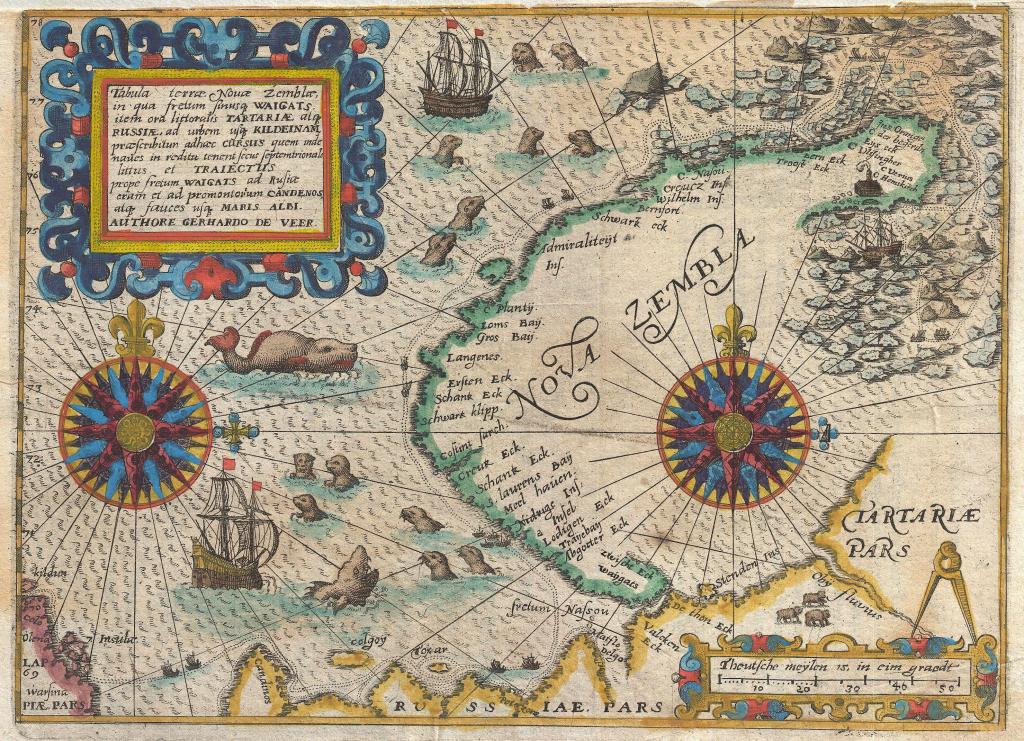
This is one of my favorite maps, because it incorporates many things that are actually quite useful for reducing the cognitive work of understanding something well enough to make adequate decisions.
An unrelated example of this is the F-22 Air Superiority Fighter. One of the things the Air Force decided to do in designing the aircraft is make the Multiple-Function-Displays as simple to glance at and understand as possible, and to entirely eliminate all small and difficult-to-read flight instruments. This is called something like an All Glass Cockpit.
To understand why this is done, imagine for some reason you needed to sit in an office cubicle, and your job for mysterious reasons was to search for and locate specific analog wrist watches and read specific times, and each wrist watch had a different time, and each was thumb-tacked more or less randomly all over the raised privacy walls of your cubical.
You can probably guess how this would create significant Office Fatigue. Well that’s exactly what it’s like for pilots in non-glass cockpits, when all they have are small mechanical instruments, as well as buttons and switches in locations that were basically unplanned. Now you can imagine how easy it would be to take off in such an aircraft, but then after a long flight, how stressful landing would be after being worn out cognitively by all the brain-work of reading all the aircraft’s instruments.
And so that’s why the Air Force wanted to make an all glass cockpit that a pilot could always find the information he needed quickly in a well designed graphical display before concentrating on matters such as shooting down another aircraft. They also wanted to minimize information to only what was absolutely crucial to the situation at hand, so that the sum-collection of all information displayed on all screens was as little as possible, because this meant a pilot could find it easier with his eyes.
And so with THAT in mind, if we look at this map from an era of early ship navigation, I’ll point out many things that I like:
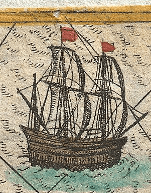
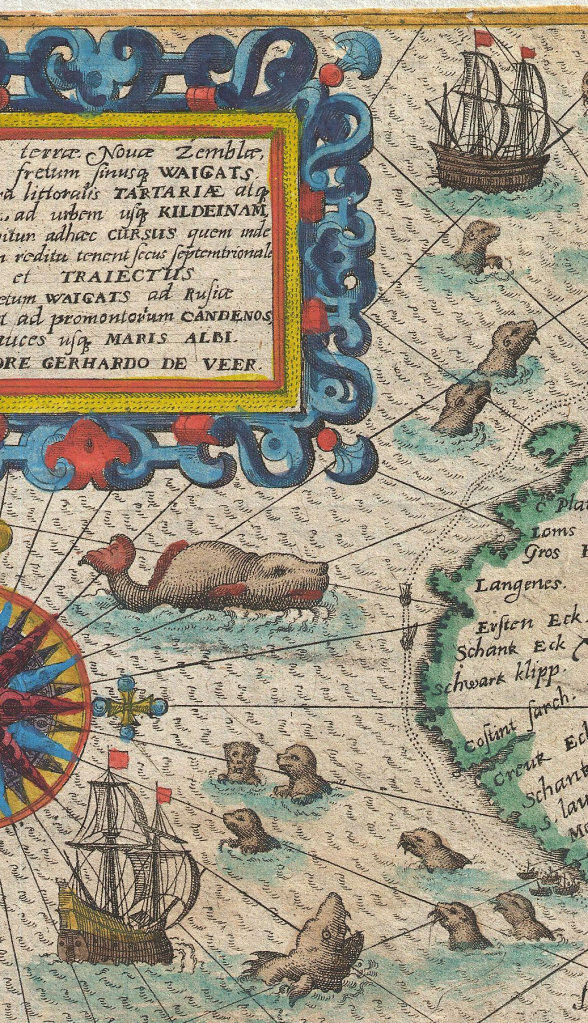
These large ship illustrations are interesting, but one thing I should really stress about old-fashioned maps of the past that incorporated fanciful drawings is that almost ALL drawings on them were useful, and were not there just because the officers navigating a ship were overly-imaginative and silly.
And so what could the purpose of these large ship drawings be? They were anchorages or drift areas, ie The clearly marked areas that a ship could stop and either anchor to remain in one location safely, or drift without anchor and not endanger itself by drifting and beaching itself on land.
How do I know this in regards to this map? Because the island is Nova Zembla located in the arctic waters of Russia, and there is always a consistent wind that blows to the southwest.
Thus the two large ship illustrations are there to show where a ship that has arrived can ‘park’ in one location, and not be in danger of rocks beneath the surface, or if without anchor, having the wind and seas slowly push the ship into land.
This was important because Nova Zembla tends to have a lot of fog, and so when a ship has arrived, they can’t necessarily navigate safely to the island because of darkness or low-visibility, and will have to wait until better conditions allow them to move the ship to the island. You also have to keep in mind that in the past, sailors didn’t know the true depth of the water unless people had been measuring it by sinking weights on cords everywhere for a very long time. This made it necessary to stay far enough away from any shore to not accidentally beach the ship or damage the hull with rocks.
And so it was nice for a ship’s navigation officer or captain to just know where to get his ship with just a glance at the map, which explains the large ship illustrations.
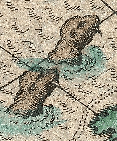
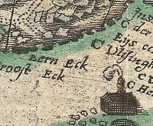
And what about the illustrations of seals? Seals were hunted significantly in the past, because their skins were used to make very warm clothing and fat was used for as fuel for oil-burning lamps. There were many other uses for seals as well on sailing vessels.
The seals are there partially for illustrative purposes, because seals are not typically stationary features possessing fixed locations which can be reliably marked on a map, but instead tend to move around a lot to the vexation of the ship’s bridge crew. They also aren’t illustrated to look pretty, because I used to be a sailor, and one of the things we were all taught is that the cute faces and black cow eyes of seals are dangerously deceiving to human beings for uncontrollable anthropomorphic reasons, and seals can seriously “F you up” with one bite, ahem.
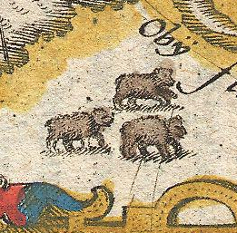
And what are these? Bears, actually. And not brown bears even though they are restored here AS brown, but POLAR Bears. In the original map, they were not colored in but left white inside. Restoration mistake.
It is rather important in the arctic to be reminded that there are polar bears. They are not afraid of anything at all, and even today have had so few encounters with human beings that ZERO genetic changes have occurred to discourage them from attacking us. This is why the bears were illustrated: So that everyone can be briefed before disembarking for land that you can’t just go out for a casual stroll.
In addition, I have some speculation that the chart-maker made a shrewd choice to not draw the bears on the island, but instead marked them in the continent of Russia. In reality the polar bears were everywhere in this area, and can swim for miles, as well as walk across the frozen water directly to the island quite freely. But as a ship’s officer, you don’t want to frighten the crew weeks away before arriving at Nova Zembla that the damn things will literally be everywhere, which is why they indicated them as all safely in Russia, and the crew would only be given guns and spears at the last possible moment before disembarking. I scored a perfect 7 in officer tricks. 😉
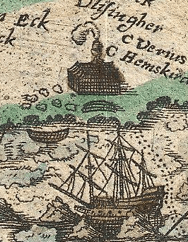
This is easy to understand. It is the location of a heated building the Dutch built in order to keep warm, cook food, and be safe from the elements and bears. It could only be reached by small boats released by the main ship. There were probably also lots of extra supplies that were left there by previous visits, because officers managing this sort of thing enjoy the numbers-game of calculating how much stuff they can leave behind and still get back safely to Western Europe, and thus build up their storage depot.
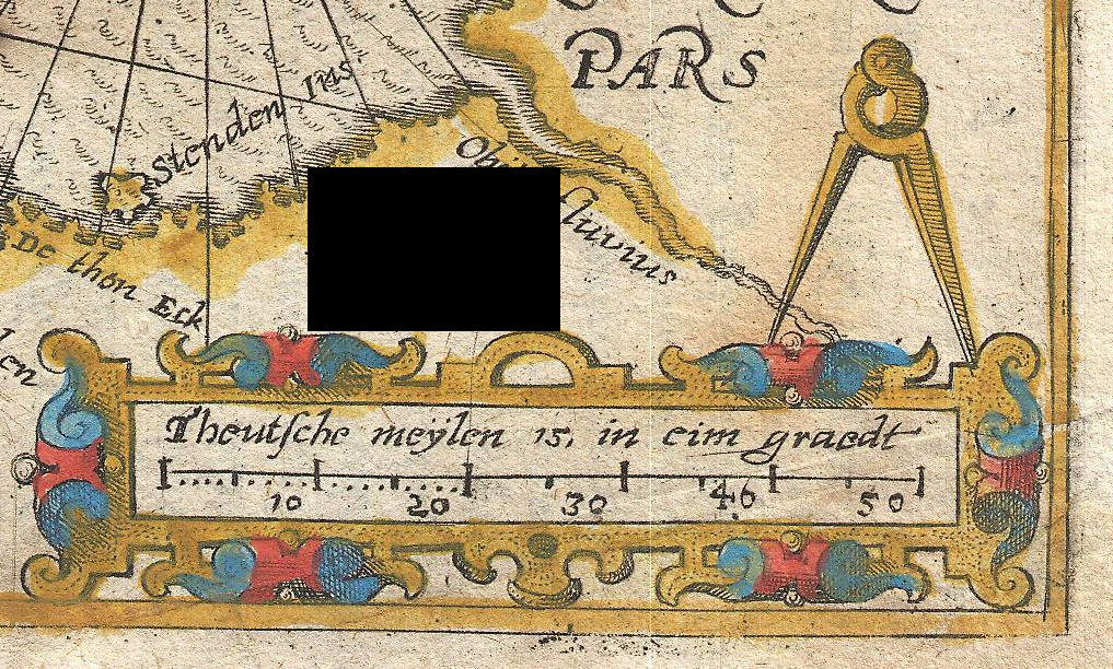
This is easy to understand as well, but there are other details I’ll describe in a moment. This is an illustration of a compass, ie The circle-drawing thing, and a scale. Compasses are used in order to take a measurement off the scale by manually adjusting the compass to the correct width, and then moving the stored-width to another place on the map for a variety of purposes.
Now I speak from experience: It is tiring to get down low over a map and then adjust a compass to a precise measurement. Compasses are awkward, lighting can be bad, the ship might be rocking in the swells and waves, ext. And so what people did then and still do today is have their favorite compass needle holes in the map. I won’t zoom in to what I believe are needle holes all over this area of the map, but they are there, and many of them measure out to useful distances and widths. This makes it much easier for someone to just quickly adjust the compass to two holes that he knows does the trick he needs, and then get on with using the compass on the map. Even the compass illustration itself may have been an approximate guide to adjusting a compass to a useful width.
That wraps up the usefulness of fanciful illustrations for quick reads of information. Let’s move on to pre-GPS navigation techniques.

Ask yourself a simple question: If you sail across the ocean over a long distance, and then finally reach another shore, if you did your navigation properly, you’ll at least be confident you reached the correct shore, but how do you find out where on the shore you are?
This is why early explorers used the coastal features of a land body as a way to figure out where they are and how they are progressing. I am speaking about hugging close to shore as you sail along it, and watching things like capes and bays go past. They would mark many things such as these on their maps, and this created a pattern to watch for by officers on the bridge observing the coast as they sailed, and as long as the pattern they observed on the coast matched the labels on the map, they knew where they were.
It is like a kind of binary system. Let’s say you only marked capes and bays and nothing else, and a cape was given a 1, and a bay was given a 2.
After reaching your shore but not knowing where you were, you can turn the ship either left or right and then begin keeping a record of capes and bays as they go past. It might look something like 12212. Once they had enough of these, the last 2 might fairly conclusively fix their position on a map where they had a match of the identical capes and bays pattern, after which they can make their further navigation decisions.
Here we see a group of four ships huddled on the island’s southwest side. This was a ‘parking’ area to allow arriving ships to huddle in a place close to the island, and the wind would be blocked by the island, and they wouldn’t drift away.

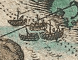
And now why do all ships in the map seem to travel in pairs? The reason is Icebreaking, except back in the late 1500’s and early 1600’s, the hulls of ships nor the power of wind and sails was enough to break ice.
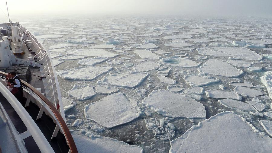
Pancake ice is the typical stuff you see before you get to the really thick and completely frozen over areas of the far north. The island of Nova Zembla is north, but not enough to require icebreaking, and so the issue that needed resolving was getting pancake ice out of the way.
How they did it is one ship would be in the lead, and if pancake ice was unavoidable, they pushed it carefully out of the path, and both ships would pass through the gap left behind. The reason they moved in pairs is because it is much more efficient getting two or more ships through a gap made by the lead ship, than just moving one ship through at a time and having more pancake ice drift in to block the route.

And that leads us to an interesting detail, which is there is no cartography of the island of Nova Zembla on its eastern side. This is because the consistent arctic wind that blew from the northeast to the southwest pushed so much drifting pancake ice into the area there that it all became piled up and impassible due to having no outlet.
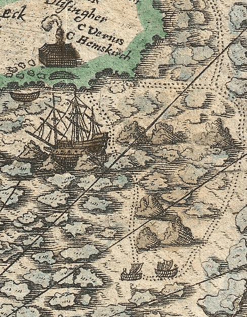
This leads to the easy ship’s planning here in the area they can get to the structure built on the island. Remembering that they used wind and sails to move their ships, then you have two easy plans here marked in double-dotted lines for successfully getting the ship close enough to the building structure before getting their small boats to shore.

And so what we have are two plans to get the closest to the structure. In the first plan which is mostly westward, you can see that the way to move westward is to configure your sails like the leftmost box. The officers would only do this if there wasn’t much pancake ice, because otherwise they would bang up their ship and get slowed down to the point of not being able to move forward.
In the second plan, you can use the top and bottom boxes, and first move their ship southward, before making a 180-degree turn northward towards shore. This would be done when there was more ice, and because the winds consistently blew to the southwest, then how much power the sails had was reduced, and so instead they would slowly poke their way through it until reaching their destination.
Here we have a third plan, also marked in double-dotted lines in the top left corner, which is used in case there is too much ice to get to the closest route to the structure on the other side of the island, and instead they get the ship to the closest north side of the island, and then the crew in small boats will walk across the island to reach the structure.

And so you can see from just these illustrations alone that it makes the planning decisions of officers almost effortless, because everything is already conceived and worked out by the cartographers beforehand, utilizing the experience of the ships that arrived at Nova Zembla on previous expeditions.

Leave a comment